
Water Source
The Black Creek Aquifer located in the Coastal Plains region of North Carolina is made up of hydraulically connected materials (sand, limestone and fractured rock). Old Saratoga water bottling plant draws water directly from the Black Creek Aquifer.
"Recent Carbon 14 age dating of the ground water in the Black Creek and Upper Cape Fear aquifers reinforces our understanding of the ground water flow patterns in these aquifers. The age of the water increased with depth and with distance from the fall line eastward and ranged from 400 years to over 26,000 years. The major source of recharge to these aquifers comes from the surficial aquifer near their westward limit. The water flows down gradient for tens of thousands of years before being withdrawn by water users in the coastal plain."
The Black Creek Aquifer is located in the central & southwestern portion of the coastal Plain. The Black Creek Aquifer has elevations of 318 to -(1477) feet averaging -(172) feet, averages 160 feet thick with ranges from 14 to 448 feet thick. The aquifer is composed of very fine to fine sand, also known as "Salt and Pepper Sands". Wells yield 200-400 gallons per minute.
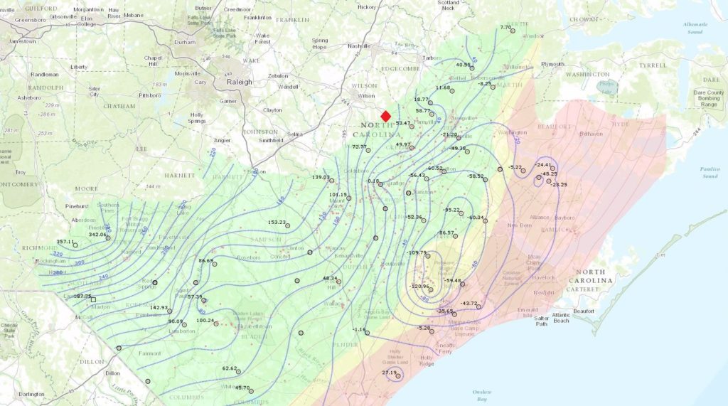
Above is an image of just how big the Black Creek Aquifer is. The image, provided by Dr. Kenneth B. Taylor, PG, State Geologist of North Carolina, represents the Black Creek Aquifer potentiometric surface averaged over the entire year of 2014. A potentiometric surface is, "A hypothetical surface representing the level to which groundwater would rise if not trapped in a confined aquifer (an aquifer in which the water is under pressure because of an impermeable layer above it that keeps it from seeking its level). The potentiometric surface is equivalent to the water table in an unconfined aquifer." The red dot on the image is Old Saratoga's approximate location.
Source(s):
*U.S. Department Corp of Engineers
*NC State University Geological Dept.
*Geocaching.com/blackcreekaquifer
*http://dictionary.reference.com/browse/potentiometric-surface
*Dr. Kenneth B. Taylor, PG, State Geologist of North Carolina